

The Essex Serpent
And sometimes you just stumble across nuggets of gold.
The other day an Instagram account appeared on our feed. “The Essex Serpent” sounded intriguing (We were totally unaware of the book or the film by the way).
A series of 7 photos of ancient local monuments and a 100km route for “gravel” bike and xc mtb. All you had to do was message the page and a gpx would be emailed to you. Well. Sign us up!Truth is we’ve been spending way longer on “gravel” type bikes (read CX bike with 35c tyres) than anything else of late. As keen mountain bikers the “gravel” bike suits. The iconic Memories of John Tomac forever in the forefront of our minds. Our local routes, although great, use the same sections, we were keen to explore some new sections and basically not do the planning and go through the trial and error process of finding yourself in an impassable cow field which is inherent with this sort of thing!
An email came back from a man called Gareth. It turns out that he is moving away from the area in the summer and started working on the route basically because he wanted to leave behind some sort of record of all the riding he has done around Chelmsford over the past six years behind. He’s a ancient / medieval history geek as well as a bike nerd and a lot of his riding has involved seeking out and trying to make sense of ancient places. The Attached GPX file is, in a way, his small legacy.

The Serpent
Well we had a free day coming up, the sun was out so off we went. Pockets full of Soreen, a banana, some water and stuff for punctures.
Unfortunately I can’t afford a house in Blackmore just at the moment so we set off from Chelmsford and the route we chose begins at Sandford Mill Lock. However the beauty of this route is that you can pick it up wherever and ride as a whole one and as long as you are either within its radius or within touching distance outside of its radius you’ve got a ready made day out.
Graces Walk. Haunted. No really...
We took Graces Walk out of town to join the route on The Ridge at Danbury. In looking for the route we ended up exploring someone’s driveway. So if you download our gpx you will find this and a few other errors, some of which will be disclosed later in this piece. The first of the way marked places of interest is the Iron Age Fort at Little Baddow. Not strictly to be ridden on or around, so approach with care. But at least we knew where that was so we made a bee line for there and picked up the purple line. From here we found our way onto North Hill and down to Paper Mill Lock and then out into the Essex country side.
As a circular route in familiar territory it was reassuring to know where we were at most times. The next segment into the village of Terling is one of our favorite roads. Quite and through tree lined lanes with a few grazing cattle it’s part of one of our old commutes to work. Onto the Boreham Road and then we found our first bit of tree lined trail which crossed the main Braintree road and headed us toward Pleshey.

A typical bridal way tunnel...
Now you would think it would be hard to miss the castle at Pleshey. But we missed it. Frankly the trails were too good to worry about it too much. We were experiencing the whole array of Essex (summer) gravel. From the type you get on peoples driveways, the bits where there isn’t any, the bits where there is some all the way to the bits where the farmer has just resurfaced with a load of old house bricks, this route has it all! The route then turned south and onto some of our favourite by-ways in and around Blackmore and Writtle. The Soreens were beginning to run out. Around here there are two way points, the clearing at Writtle Woods (the site of a 12th century Hermitage) and the mysterious Moores Ditch (a linear earthwork in the woods near The Cricketers/The Viper public houses which would make excellent lunch stops by the way). Regardless of the waypoints the mix of trail on this ride is excellent. From single track to double track, ancient woodland and quite lanes it’s all there. Alongside “gravel” of all shapes and sizes…

Keep mooving
Under the A12 we went and into Ingatestone High Street (a little off route but there’s a bakery in Ingatestone) we went. At this point a bath bun was on the cards. Running out of water but some Audax experience told us we would find some water somewhere, generally at a churchyard tap. Cherry Coke and Bath Bun inhaled I put a BLT baguette in my back pocket for luck and if you follow our gpx you will then do a lap of Ingatestone church in search of an outside tap. There is no tap here.

A welcome cake break in Ingatestone.
Onto Billericay where the route gets a little messy but once you get into Norsey Wood and the next way point (a Bronze Age burial mound) you’ll find some great single track that takes you into Ramsden Heath where at kilometre 77 we were rescued as the bridleway delivered us right to the doorstep of Mark Groves’ workshop. Fortunately he had a tap, as we were close to harrassing local gardeners for the use of their hosepipes… (wahay). (A point to note before you get to Billericay you get to a rather imposing set of gates to a horse farm, there is a button to let you in, it’s totally legit but doesn’t feel that way. I met the farm owner, it’s cool. But you do feel like someone might shoot you for trespassing and indeed you may become part of your own bronze age burial mound!)

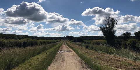
The route takes in some of the Essex's best countryside.
On we went and frankly I was now tiring. Maybe the extra weight of the baguette was weighing me down but in reality my 90min Zwift timer went off ages ago and I was powering down with every pedal stroke after. Fortunately this route does have a nice amount of lanes so ground does get covered. A footpath from Rettendon added to our collection of lacerations and nettle stings and into Bicknacre where we once again missed a massive arch that are the remnants of a 13th century priory. You can’t win them all! With the Garmin saying it was running out of battery the route was turned off we freestyled back past the Lepers Graveyard on Moores Hall Lane and up to Danbury and to the bench that had been earmarked to finally eat lunch which had been carried around for the last 50km! The loop was done and even though half the way markers had been missed we can honestly say this is one of the best rides we have done locally, if not the best. Beautiful countryside, some good potential stopping points with minimal research and a fantastic mix of surfaces (in the dry!!) For those of you thinking of doing this I would recommend getting the route from Gareth via instagram (@essex_serpent_bike) or searching in my routes (I will try and link it HERE) as I will attempt to save a version which irons out my errors and finds a smoother way through Billericay, if indeed I can do that (EDIT, I can’t, email Gareth or put up with a couple of dead ends!).
Finally a huge thank you to Gareth for sharing this and allowing us to write it up. Give him a follow on IG, ride it, share the love!

Uuuuummmm. Gravelicious.
Cake Options (there will be others, don't @ me)
The Bakery/Tea Room at Eve's Corner Danbury (3 o'clock on the map)
Papermill Lock Tea Rooms (3 o'clock)
Owl Hill Tea Rooms, Terling (2 o'clock)
The Viper (currently due to reopen) & The Cricketers PH's, Mil Green (8 o'clock)
Ravens Bakery, Ingatestone (8 o'clock)
Travel
Trains run from London to both Ingatestone (Norwich) and Billericay (Southend) which are both on the route or you could go to Chelmsford and take our route out which would probably be the best from Chelmsford Station using National Cycle Route 1.